USFS Motor Vehicle Use Maps
Most of our areas trails and routes are found either in the Payette National Forest or the Boise National Forest which surround McCall, Donnelly and Cascade (Valley County). Visit the following links for current information from each agency and as well as direct links to surrounding trail and motor use vehicle maps.
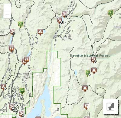
McCall, ID – West, North & East
Official USFS Website Page: Payette National Forest – Maps & Publications Page
- [ USFS Motor Use Vehicle Map: West of McCall ] / [ Avena ]
- [ USFS Motor Use Vehicle Map: North & East of McCall ] / [ Avenza ]
Cascade, ID – West, South & East
Official USFS Website Page: Boise National Forest – Maps & Publications Page
- West, South & East of Cascade [ USFS Motor Vehicle Use Map 2023 – West Half ]
- Warm Lake, Yellow Pine [ USFS Motor Vehicle Use Map 2023 – East Half ]
- East Mountain, Sage Hen Reservoir [ USFS Motor Vehicle Use Map 2023 – West Half ]
- East Mountain, Deadwood Reservoir, Lowman & Garden Valley [ USFS Motor Vehicle Use Map 2023 – East Half]
- Deadwood Reservoir, Lowman, Bear Valley [ USFS Motor Vehicle Use Map 2023 – Lowman ]
- [ Cascade Ranger Trail Map District ]
- [ Emmett Ranger District Trail Map – West ]
- [ Emmett Ranger District Trail Map – East ]
- [ Loman Ranger District Trail Map ]
The Motor Vehicle Use Map (MVUM) is the legal document that shows where it is legal to drive a motor vehicle. The MVUM is re-published every year, so, please be sure that you are using the most current version when driving on the National Forest.
The MVUM is a black and white map with no topographic features. It is a map for legal designations of where you can travel with various motorized vehicles, but for additional reference it is best used in conjunction with a Forest Visitor Map or other detailed map.
Direct Links to National Forest Service Websites:
[ Payette National Forest Service Home ]
[ Boise National Forest Service Home ]
Forest Service Alerts & Notices