Snotel Sites
You can view current and past snow condition data through NRCS and NOAA. Both display the same data but in a little different format, one or the other may be easier to view depending on your device so check out both options. The buttons provide links to interactive maps and then there are lists of specific sites. For current Idaho basin conditions, click here.
NRCS Snotel Sites
For current and past snow depth, snow water equivalents, air temperatures and more, visit the NRCS Snotel Interactive Map via the button below. The Snotel sites are indicated by colored dots. Hover over a dot for the current snow depth. Click the dot for more information and then click “Data Reports” for a list of more detailed reports or the site page. The interactive map has many control options so be sure to check it out on a full sized computer for the easiest experience. For help with the interactive map and saving settings, click here.
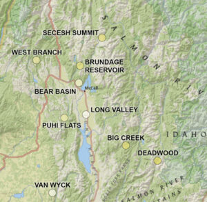
Direct links to Snow Depth data reports for the last 7 days at the following specific sites:
- Secesh Summit (North of McCall @ 6,520 feet in elevation.)
- Brundage Reservoir (North of McCall @ 6,250 feet in elevation.)
- Bear Basin (McCall area @ 5,350 feet in elevation.)
- West Branch (Northeast of Price Valley / West of New Meadows @ 5,560 feet in elevation.)
- Long Valley (Between Lake Fork and Donnelly @ 4,890 feet in elevation.)
- Puhi Flat (West of Donnelly @ 6,240 feet in elevation.)
- Big Creek Summit (Northeast of Cascade @ 6,580 feet in elevation.)
- Deadwood Summit (East of Cascade @ 6,860 feet in elevation.)
- Van Wyck (West of Smith’s Ferry @ 4,920 feet in elevation.)
NOAA Snow Station Information
NOAA provides another way to view snow depth and water equivalent data. Click the button to be taken to the interactive map and click on the color dots or click the links below for direct access to that specific site’s data depicting easy to read charts and graphs.
- Sechesh Summit (North of McCall @ 6,520 feet in elevation.)
- Brundage Reservoir (North of McCall @ 6,250 feet in elevation.)
- Bear Basin (McCall area @ 5,350 feet in elevation.)
- West Branch (Northeast of Price Valley / West of New Meadows @ 5,560 feet in elevation.)
- Squaw Flat (West of Donnelly @ 6,240 feet in elevation.)
- Long Valley (Between Lake Fork and Donnelly @ 4,890 feet in elevation.)
- Big Creek Summit (Northeast of Cascade @ 6,580 feet in elevation.)
- Deadwood Summit (East of Cascade @ 6,860 feet in elevation.)
- Van Wyck (West of Smith’s Ferry @ 4,920 feet in elevation.)
Snow Coverage Per Basin
Check out the interactive map for current snow coverage in the Northwest.