Snowmobile Trail Maps & Riding Areas
There are numerous ways to view snowmobile trail maps for McCall, Idaho. Some are a downloadable PDF file that you can view on your computer or smart phone as well as print, some use viewable in apps that you download to your smart devise and some are viewed online in your computer browser. Be aware that some off road map sources do not provide the most accurate trail status or designation so be sure to use the most up-to-date official map provided by or endorsed by the National Forest Service and/or Idaho Parks and Recreation Department.
Idaho Parks & Recreation Interactive Trail Map
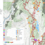
For an interactive map of Idaho’s snowmobile trails, parking areas, snowmobile trail grooming status and areas closed to snowmobiling, visit the Idaho Parks & Recreation online map application via the button below. Also visit McCall Snowmobilers website, the Payette US Forest Service website and Idaho Parks and Recreation “SNOWMOBILING IN IDAHO” brochure for additional information on snowmobiling and over snow travel in our area and Idaho.
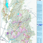
McCall Area GeoReferenced Snowmobile Map
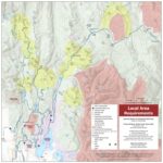
Download the McCall Chamber’s new georeferenced pdf map to use in apps like Avenza. The McCall Area Snowmobile Club has also helped identify “Play Areas” that make great destinations for experienced riders to explore off-trail.
Payette National Forest Winter Travel Maps for Avenza App
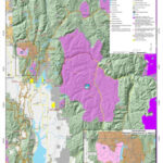
For live GPS map tracking, download the free “AVENZA” app to your smartphone then download the “Payette National Forest Winter Travel Maps“ via the buttons below. The app will track you via a blue dot on the map as you ride! Map provided by the Payette National Forest and sponsored by local clubs, the Idaho State Snowmobile Association and other area businesses.
Payette National Forest Service PDF
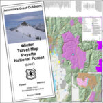
Click the button or image to download a snowmobile trail map for McCall, Donnelly, Cascade & New Meadows in the PDF form.
For more over-snow travel information, snowmobile maps and snowmobile regulations from the Payette National Forest Service, visit the following links:
- Payette NFS – Snowmobiling Information
- Payette NFS – Maps & Publications
- Payette NFS – Travel Management Planning
Boise N.F.S. Winter Travel Map
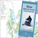
For over-snow travel information, snowmobile maps and snowmobile regulations around Cascade, Smith’s Ferry, Warm Lake, Garden Valley and Yellow Pine, visit the Boise National Forest Service website links below. You must use the Avenza app on your mobile device to view this free snowmobile trail map.
- Boise National Forest Service – Winter Sports: Snowmobiling
- Boise National Forest – Maps & Publications
Garden Valley Snowmobile Grooming Map
For groomed snowmobile trails, parking area, milage, gas and food, landmarks and features along with other area information around Garden Valley, Idaho, download the following Forest Service PDF map. Garden Valley is located between Boise and McCall, east of Banks, Idaho. There are routes through the mountains that can be used by snowmobiles to travel between the Round Valley area (south of Cascade, Idaho/southern end of Valley County) to the Garden Valley area.